Du verwendest einen veralteten Browser. Es ist möglich, dass diese oder andere Websites nicht korrekt angezeigt werden.
Du solltest ein Upgrade durchführen oder einen alternativen Browser verwenden.
Du solltest ein Upgrade durchführen oder einen alternativen Browser verwenden.
Das Google-Earth Quiz
- Ersteller Philipp87
- Erstellt am
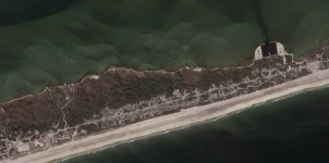
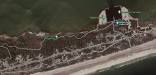
Das Quadrat ist ein Hafen.
Um das von der Größe her einzuordnen:
Diese Nehrung (wenn man es so nennen möchte) ist auf Höhe des Hafens ca. 250m breit.
Sie ist aber wesentlich!!! länger!
Der Wald ist das Besondere... das ergibt sich dann aber.
Ihr seid auf Zack!
Um das von der Größe her einzuordnen:
Diese Nehrung (wenn man es so nennen möchte) ist auf Höhe des Hafens ca. 250m breit.
Sie ist aber wesentlich!!! länger!
Der Wald ist das Besondere... das ergibt sich dann aber.
Ihr seid auf Zack!
Fire Island

 npplan.com

Fire Island National Seashore | SUNKEN FOREST NATURE TRAIL
The Sunken Forest Nature Trail is a 1.6-mile loop that passes through a maritime forest found at Fire Island National Seashore.
Zuletzt bearbeitet:
On most barrier islands, a main sand dune forms on the ocean side, protecting all the vegetation that grows behind it from wind and salt spray. Here at the Sunken Forest, a second, smaller dune has formed behind the main ocean-side dune. Protected from salt spray and elevated high enough to keep vegetation out of the low-lying saltwater marsh that borders the bayside shore, trees took root on the slopes and top of the secondary dune creating a unique maritime forest. Because some of the trees grow on the slopes of the dune, the forest appears to be sinking, which is where the name Sunken Forest comes from.
It is also interesting that the trees on the secondary dune will only grow as high as the main dune because branches that attempt to grow higher end up dying after getting hit with salt spray that passes over the top of the main dune. The result is what looks like a forest of short Bonsai trees.
Teilen:
Online-Statistiken
- Zurzeit aktive Mitglieder
- 7
- Zurzeit aktive Gäste
- 452
- Besucher gesamt
- 459
Die Summen können auch versteckte Besucher enthalten.


